I mentioned last week that there was the potential for a snowstorm in the Thursday to Friday timeframe. Since then, there has been very little model consistency regarding any potential storm. Most of the models have shown that little pieces of energy would rotate through the area following yesterday’s rain storm. What keeps these pieces from turning into a major storm is the lack of phasing with the subtropical jet and therefore, lack of major moisture.
The models had been consistent in showing that scenario for tomorrow and Thursday… until last night. Last night, the NAM model showed energy from Canada phasing with energy from the south basically right over us, and producing a major storm just to our north. We need this phase to occur to our south in order for the system to impact our area.
This afternoon, the GFS model showed this solution:

Here you can see the energy (yellow) coming out of Canada and meeting up with the energy coming out of the Gulf of Mexico.
This merger takes place to our south and results in this:

The low forms to our south and begins to move up the coast. The GFS has this low intensify rapidly and moves it into New York state, and eventually loops it back down towards Maryland.
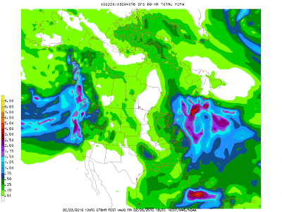
The end result…

This map shows the total precipitation in liquid inches. As you can see, there is a sharp gradient right over our area with extreme NE Maryland approaching 1.50″ and NE Virginia only in the .25-.50″ range. A standard 10 to 1 ratio would indicate that anywhere from 2.5″ to 15″ could fall as you move from southwest to northeast across the state. Of course, this makes the forecast extremely tricky. Any deviation in the track will have major implications on how much snow falls across the state.
Another issue with this storm will be the wind it produces. As this low moves up the coast and “bombs out” winds will increase dramatically. Winds could gust to 60mph+ on Thursday.
This is an extremely complicated forecast and that is why it has not been modeled well. However, there is enough confidence at this point for the National Weather Service to issue a Winter Storm Watch for the Northern and Eastern parts of the state, but even they aren’t as confident as they would like to be:
12Z GFS WOULD CERTAINLY BRING MORE SNOW TO PORTIONS OF THE CWA IN THE WEDNESDAY NIGHT THROUGH THURSDAY NIGHT TIME FRAME…ESPECIALLY ACROSS NORTHEAST MD. WILL NOT BE QUITE AS WEST/AGGRESSIVE AS GFS AND ITS RUN TO RUN CONSISTENCY WILL NEED TO BE CLOSELY EXAMINED OVER THE NEXT DAY OR SO. BUT WITH ENSEMBLE SUPPORT AND THE 12Z ECMWF TRENDING A LITTLE MORE THIS WAY…WILL INCREASE POPS/QPF ESPECIALLY NEAR THE I-95 CORRIDOR AND NORTHEAST MARYLAND FOR SNOW. 50 PCT CONFIDENCE FOR WARNING SNOWFALL CRITERIA /5 INCHES IN 12 HOURS OR 7 INCHES IN 24 HOURS/ EXISTS ACROSS NORTHEAST MARYLAND AND A WINTER STORM WATCH WILL BE ISSUED. THIS MAY BE A STORM WITH A TIGHT GRADIENT OF SNOWFALL…WHICH ADDS TO THE CHALLENGING NATURE OF THIS STORM. SO PLEASE STAY TUNED AS THIS TIGHT GRADIENT COULD CUT THROUGH THE DC METRO AREA.
Stay tuned and as the details come into better focus, I will update the situation.
