Another fairly warm day today with high temperatures into the 50s in most spots. There is a chance for some light rain this afternoon as a warm front will be basically draped across the state. Things get a little interesting tonight as the warm front sags south of the area and another, more potent area of low pressure moves in from the west.
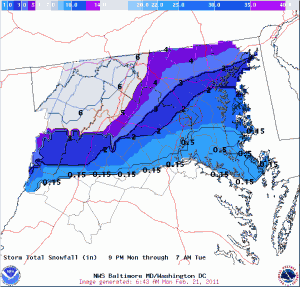
Expect the rain to mix with sleet and snow, and eventually turn to all snow tonight. Expect 1-3″ of snow to accumulate mainly on grassy surfaces, with the higher amounts near the Mason-Dixon line and lesser amounts as you go south.
Here is how the NWS currently sees it playing out:

Temperatures will return to around normal for the middle of the week, before modifying a bit towards the end of the week before another cold front moves through Friday into Saturday.
