A frontal boundary is still in the area and as a result, there is still a slight chance of afternoon thunderstorms today. Otherwise, it will be mostly sunny and hot with heat indices over 100 this afternoon.
An Excessive Heat Watch is still in effect for tomorrow as heat indices are expected to top 110. Temperatures will be even warmer on Friday with highs in the low 100s and heat indices approaching 115. The heat continues into the weekend with highs on Saturday again around 100 before “cooling” back to the mid 90s on Sunday.
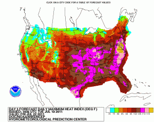
Check out this map below (Click to enlarge.) These are the forecast high heat indices for Friday.
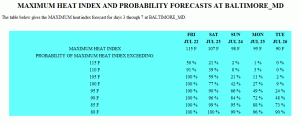
From that map, here are the details for BWI (again, click to enlarge.) NCEP is giving us a 50% chance of the heat index going over 115 degrees on Friday!


