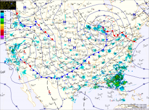
Expect sunny skies and warm conditions today, with temperatures approaching 60 today. Unlike Friday we will not be relying on a warm front to bring in the milder air, so there is no chance that the warmth stalls out to our south today. A weak, dry cold front will move through later today and it will usher in slightly cooler air for tomorrow, but sunshine will remain.
A stronger area of low pressure will move into the Great Lakes Tuesday night and Wednesday, bringing moisture and rain to the area on Wednesday and Wednesday night. Rainfall totals may approach an inch with this system.
After the rain on Wednesday, we will dry out on Thursday and Friday with temperatures near 50 both days. Another system will affect the area on Saturday, with more rain likely.
Also, I wanted to point out that we have added new maps to the site. If you go to the menu and mouse over “Current Maps” you will see “Surface Maps” and “Upper Air Maps” in the drop down list. The surface maps are updated hourly, and the upper air maps are updated at 0z (7pm) and 12z (7am). Hope you find them useful!
