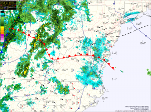
A warm front is currently working it’s way through the state, allowing moisture and warmer temperatures to stream northward. This feature, combined with a cold front approaching from the west will provide the forcing necessary for shower and thunderstorm development.
At this time, it appears enough instability and lift will be present for some of these storms to become severe and produce damaging winds, large hail, torrential rain and possibly tornadoes.
Expect storms to develop this afternoon, and then a second round of storms as we head into tonight as the cold front crosses the state. Highs today will be around 80 degrees.
The front will clear the area tonight and northwest flow will bring in cooler and drier air for Saturday. Expect a mix of clouds and sun tomorrow, with highs in the mid 70s.
We will remain under the influence of the current storm system Sunday through midweek as it sits over New England. This will allow for a slight chance of showers each day while temperatures are held in the mid 70s.
Please keep an eye to the sky and be alert for watches and warnings as they will likely be issued this afternoon and tonight.
