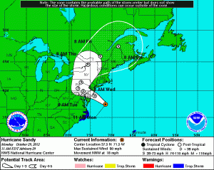

Minimum central pressure is 943mb (27.85″). For comparison, the 1938 New England hurricane was the strongest to ever hit the Northeast. That storm’s lowest pressure was 938mb and was a Category 3 at landfall.
Sandy is beginning to transition to a post-tropical storm and as it does, further strengthening is possible.
Conditions will continue to deteriorate throughout the day today as Sandy approaches.
Expect winds to continue to increase and gust to near 70mph by tonight. This wind will continue through tomorrow morning before Sandy begins to move northward through Pennsylvania and away from our area.
