This blog post will be updated as needed with updates on the forecast and progress of Hurricane Sandy.
Please check this post periodically for updates. I will also update Facebook with any new information.
8:30am Update:

-Flood Warning for counties along the Bay
-Coastal Flood Advisory for Western shore of Bay
-Coastal Flood Warning for counties along the Potomac and for the Atlantic Beaches
-High Wind Warning for entire state
-Blizzard Warning for Garrett County
-Hurricane Force Wind Warning for the Chesapeake Bay and Atlantic Coast
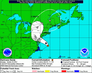
Sandy has made the turn and is now heading NNW at 20mph. A continued turn to the NW and eventually WNW will bring Sandy inland near the Delaware Bay.

Maximum Sustained Winds: 85mph
Minimum Pressure: 946mb (27.94″)
Moving NNW @ 20mph
Hurricane force winds extend up to 175 miles from the center and Tropical Storm force winds extend 485 miles from the center.

By early Wednesday morning, the storm should begin to move northward into New York and away from our area.
Winds will increase steadily through the day today with maximum gusts to near 70mph from late this afternoon through tomorrow morning.
A total of 6-10 inches of rain are expected for central and eastern Maryland with locally higher amounts.
4-8 inches of rain are expected further west, while 2-6 inches are likely across far western Maryland.
The combined wind and heavy rainfall will cause wide spread and significant tree and power line damage.
Here are some precautions from the National Weather Service:
PRECAUTIONARY/PREPAREDNESS ACTIONS
———————————-
* BE PREPARED FOR EXTENDED POWER AND COMMUNICATIONS OUTAGES.
* IF YOU LIVE NEAR LARGE TREES…REMAIN IN THE LOWER LEVEL OF YOUR
HOME OR SEEK SHELTER ELSEWHERE IF POSSIBLE AND RIDE SANDY OUT.
* REFRAIN FROM ANY UNNECESSARY TRAVEL.
* ENSURE LOOSE ITEMS ON YOUR PROPERTY ARE SECURED.
* IF POWER LINES ARE DOWN…STAY AWAY FROM THEM AND REPORT IT TO YOUR
LOCAL ELECTRICAL UTILITY COMPANY.
* IF YOU SHOULD HAVE EMERGENCY TRAVEL…IF YOU COME UPON FLOODED
ROADWAYS DO NOT ATTEMPT TO CROSS SUBMERGED ROADWAYS. TURN AROUND
AND DONT DROWN.
* IF YOU USE A PORTABLE POWER GENERATOR…PLEASE FOLLOW
MANUFACTURERS INSTRUCTIONS AND ENSURE THAT IT IS PROPERLY
VENTILATED.
* DO NOT USE CHARCOAL GRILLS IN ENCLOSED AREAS.
* MARINERS SHOULD ENSURE THAT THERE IS ENOUGH SLACK LINE IN THEIR
BOAT`S MOORINGS TO ACCEPT A BLOW OUT TIDE TODAY AND HIGH TIDES
TUESDAY.
* PERIODICALLY CHECK ON YOUR ELDERLY NEIGHBORS AND FAMILY MEMBERS
TO ENSURE THEY ARE SAFE.
