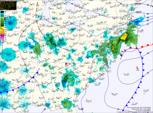
The storm is currently situated off the Delmarva coast this morning. It will continue to strengthen as it moves north and will also continue to push light wintry precipitation into the state. Winds will increase today and into tomorrow, gusting to around 30mph.
Light precipitation has pushed into central Maryland where a light rain/snow/graupel mix is currently falling. Further south and east, light rain is falling.
The mix across central Maryland will eventually change to all snow later this afternoon and into this evening as colder air flows in from the north and evaporative cooling continues. The heaviest precip will fall late this afternoon and evening and the snow will taper off overnight.
A Winter Weather Advisory is in effect for Baltimore, Carroll, Harford, Cecil and Kent counties. Snowfall totals of 1-4 inches are expected in these areas with less south and more north and east.
Elsewhere across central Maryland, up to an inch on grassy surfaces is expected.
Southern and eastern Maryland will remain mostly rain.
Skies will begin to clear tomorrow, but it will remain windy with gusts of 25-30mph likely. Highs will be in the mid to upper 40s.
A dry stretch and warming trend will commence on Friday. Highs will push into the low 50s Friday, mid 50s Saturday and will be near 60 degrees on Sunday all under mostly sunny skies.
Temperatures will push well into the 60s on Monday before a cold front approaches on Tuesday.
Yesterday’s Weather Station Stats:
High Temp: 45.8°
Low Temp: 27.1°
Rain: 0.00″
