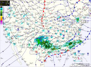
Clouds will increase tonight ahead of an area of low pressure. The low, currently over eastern Texas, will move northeastward and off the mid-atlantic coast tomorrow night.
The exact track of the storm will determine how much and of what type of precipitation falls. Current thinking is light rain will develop tomorrow afternoon, gradually changing to snow tomorrow evening into tomorrow night.
Several inches of snow seems likely, especially across northern Maryland. Further south, an inch or two of snow is likely across central Maryland while southern Maryland sees mostly rain.
The snow will end early Thursday morning and partial sunshine will return to by the afternoon. Highs will be in the mid 40s.
Friday will be another dry and relatively mild day. Highs will be in the upper 40s.
Another storm system may develop along the Gulf Coast and could bring another chance of snowfall to the area over the weekend.
Yesterday’s Weather Station Stats:
High Temp: 54.9°
Low Temp: 36.7°
Rain: 0.44″
