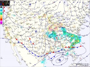
If this were January 24th instead of March 24th, there would be no question that this would be a major winter storm for the entire region. Instead, despite an abundance of cold air aloft, the late March sun will warm the surface and result in a complicated forecast.
The models have come into a general agreement on the storm track and the amount of precipitation that falls and in the far western Maryland mountains where all snow is likely, totals near 12″ are likely. Accumulating snow will begin falling late this afternoon in this area.
Further east, mixing and warmer low level temperatures will complicate the forecast. Current thinking is that light rain or rain/snow mix will begin late this afternoon or evening, turning to all snow tonight.
Temperatures will be hovering around freezing, and a warm ground will limit accumulations and confine the to mainly grassy and elevated surfaces. An inch or two of snow is possible by morning, and mainly west of I-95.
Tomorrow morning, as the low strengthens off the coast, there will be a battle between the colder air aloft being brought to the surface in heavier precip and the sun warming the low levels of the atmosphere.
Currently, it looks as though the sun will win out and turn the snow to a rain/snow mix or even all rain by Monday afternoon across central and eastern Maryland.
West of I-95 will also transition back to a mix while the mountains remain all snow.
The precipitation will come to an end late tomorrow afternoon.
Snowfall Forecast by county:
8-12″ – Garrett
4-8″ – Allegany
2-4″ – northern Baltimore, Carroll, Frederick, western Howard, western Montgomery, Washington
1-2″ – southern Baltimore/Baltimore City, Cecil, Harford, eastern Howard, eastern Montgomery
1″ or less – Anne Arundel, Calvert, Charles
Little to no accumulation expected elsewhere.
