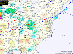
Easterly flow will develop behind the front this evening, bringing in cool and moist air overnight.
Southerly flow will take over tomorrow, scouring out the cool/damp air and replacing it with warm humid air. Highs will push into the low to mid 70s.
A cold front will approach on Friday. Ahead of the front, showers and thunderstorms will develop and move into the area Friday afternoon. Some of the storms may produce gusty winds and locally heavy rain. Highs on Friday will be in the mid 70s.
Rain chances will continue Friday night into Saturday morning, before high pressure builds in. This weekend will be cooler, with highs in the upper 50s to low 60s.
Onshore flow will likely develop again by early next week, bringing a return to cool and damp conditions Monday and Tuesday.
Yesterday’s Weather Station Stats:
High Temp: 72.8°
Low Temp: 50.2°
Rain: 0.00″
