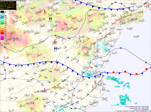
High pressure will continue to build in tomorrow. As a result, expect a mix of clouds and highs in the mid 80s.
The high pressure will move to our south and off the coast by Saturday. As it does, southerly flow around the high will pump warmer air and higher humidity into the area. This will provide a slight chance of an isolated shower or thunderstorm during the afternoon hours. Highs on Saturday will be in the upper 80s to near 90.
There is a slightly better chance of showers and thunderstorms on Sunday afternoon. Highs will be in the upper 80s.
A cold front will approach and move through on Labor Day. This will bring yet another round of showers and storms Monday afternoon and evening.
Behind that front, cooler and drier air will move in for the latter half of the week.
Yesterday’s Weather Station Stats:
High Temp: 84.1°
Low Temp: 71.5°
Rain: 0.02″
