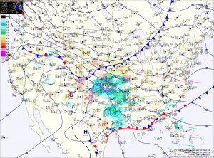
Along northern and western Maryland, a Winter Storm Warning has been issued. Expect snow to develop this evening, changing to sleet and then freezing rain. The freezing rain will likely last through the morning before temperatures warm above freezing tomorrow afternoon. Several inches of snow and sleet may fall, followed by up to 1/3 inch of ice from freezing rain.
Further south, into central Maryland, a Freezing Rain Advisory has been issued. Expect snow and sleet to develop this evening and change to freezing rain later tonight. Up to 1/10 inch of ice is possible before temperatures rise above freezing tomorrow morning, changing the freezing rain to plain rain.
Southern Maryland and the lower eastern shore will quickly rise above freezing and see mostly rain.
All of the precipitation should end during the early afternoon hours tomorrow. Highs will be in the low 40s.
Thursday and Friday will be quiet weather days with highs in the mid 30s.
The last and possibly the most significant storm in this series will likely affect the area Saturday and Sunday. Models continue to show a possible storm affecting the area with more wintry precipitation. The details of this storm will continue to develop over the next few days.
Yesterday’s Weather Station Stats:
High Temp: 45.9°
Low Temp: 30.8°
Rain: 1.33″
