A Winter Storm Watch is in effect for tomorrow for: Allegeny, N. Baltimore, Carroll, Frederick, Garrett, Harford and Washington counties.

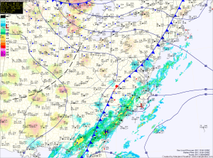
An area of low pressure is forming along a cold front off of the South Carolina coast. The low will move northward tonight and tomorrow, bringing rain to the area tonight.
As colder air pushes in from the north, the rain will change to snow from west to east during the day and into the evening. The potential exists for several inches of snowfall with more in the western portions of the state and less on the eastern shore.
The storm will pull away from the area tomorrow night, bringing an end to the precipitation. There may be some left over snow or rain showers Thursday morning but the day will be mostly dry.
Snowfall Accumulation Forecast

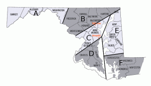
Zone A: Rain changes to snow by tomorrow morning with 4-6″ expected before ending during the evening.
Zone B: Rain changes to snow tomorrow morning with 3-5″ expected before ending during the evening.
Zone C: Rain continues into tomorrow afternoon and changes to snow during the late afternoon or evening with 1-3″ expected before ending during the late evening.
Zone D: Rain continues through the day tomorrow and changes to snow tomorrow evening into tomorrow night with 1″ expected before ending during the late evening.
Zone E: Rain continues through the evening tomorrow before possibly ending as a bit of snow. Less than 1″ expected before ending tomorrow night.
Zone F: Rain, possibly heavy at times. 1-2″ of rain possible before ending tomorrow night. It will also be breezy with winds gusting to around 20mph.
