
– Winter Storm Warnings have been issued for the entire state
It is currently 40° here in Millersville after a high of 46° this afternoon. Temperatures will continue to drop through the night, causing the rain to mix with sleet and snow and eventually changeover to all snow during the overnight and morning hours tomorrow. A wave of low pressure will continue to push moisture into the cold air through the day tomorrow resulting in a widespread significant snowfall.
As a result, Winter Storm Warnings have been issued for the entire state, a pretty rare occurrence.
There have been some fluctuations in the models today with the GFS and NAM lowering totals and shifting the snowfall south, while the Euro hasn’t budged.
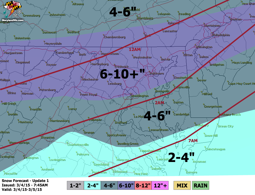
Right now, it appears the heaviest snowfall will occur during the mid morning into mid afternoon hours, with steady snowfall likely through the afternoon and then tapering off in the evening. Travel will become very difficult tomorrow as snow accumulates and temperatures drop into low 20s by the afternoon. Be very careful if you must venture out. The snow will taper off during the evening hours and sharply colder air will move in, dropping overnight lows into the single digits and low 10s.
Sunshine will return on Friday but it will remain cold, with highs only topping out in the low to mid 20s.
I will post occasional updates through the storm tomorrow with more frequent updates and reports on the Facebook page.
Stay up to date with storm information on your favorite social media site!
Follow me on Twitter, Facebook and Google+!