Cool and Damp Today and Tomorrow; Periods of Rain Tomorrow Night – Sunday Night
Summary: A cold front stalled to our south will provide a path for areas of low pressure to move through this weekend. We remain on the north side of a…

Everything you need to know about the weather in Maryland
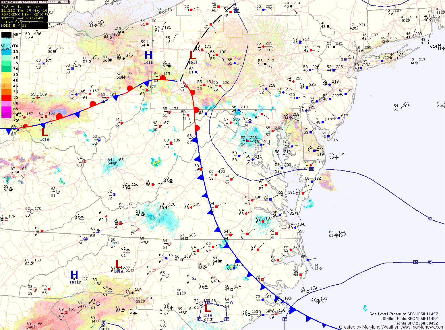
Areas of fog will develop tonight as the easterly flow continues.
As we head into tomorrow, high pressure will begin to build in from the northwest. This will scour out the moisture and turn the flow to a more northerly direction. As a result, expect morning clouds to break allowing some afternoon sunshine. There is a slight chance of a shower during the late afternoon, but most areas will remain dry. Highs will be in the low to mid 70s.

Another round of fog/drizzle is expected tonight as Atlantic moisture moves back in.
Tomorrow will be similar to today, starting off with fog and drizzle but warming up into the low to mid 80s. There is a slight chance of thunderstorms during the late afternoon and evening hours.
A cold front will approach on Saturday, spreading scattered showers and thunderstorms into the region. Highs will be in the upper 70s to low 80s.
A disturbance will move along the front tonight, bringing another chance of showers and possibly a thunderstorm during the overnight and into tomorrow morning.
Skies should then gradually clear and afternoon highs should push well into the 70s.
Onshore flow should keep clouds in the area and may result in mist or drizzle tomorrow night into Friday morning.
A WINTER WEATHER ADVISORY remains in effect for: Allegany and Washington counties.
As the latest storm system pulls away from the area, expect areas of light snow or flurries to continue over the next few hours, gradually coming to an end.
The storm generally behaved as expected, except it was colder to start and the area of heavier snow set up farther north than anticipated. Bands of heavy snow set up over central Maryland, greatly increasing snow totals. In general, 5-10″ fell across central and southern Maryland, with lesser amounts to the north. It was a tricky forecast and we certainly got a lot more snow than forecast, thanks to the enhanced banding.
Clouds will decrease slightly tomorrow morning before increasing again ahead of a cold front. The front will bring showers to the area tomorrow night. Highs will be warmer than today, pushing into the mid 60s ahead of the front.
The front will slow down and possibly stall out over the area on Friday. Expect periods of rain through the day on Friday and into Friday night. Highs will top out in the upper 50s.
Coastal low pressure remains off the Delmarva coast this morning, continuing to push rainfall into our area. 2-3″ of rain has already fallen across the area, and another 1-2″ is possible today into tonight. Highs today will be in the low 60s.
Periods of rain will continue tonight and into tomorrow morning before tapering to drizzle as the low continues to weaken and slowly move away. Even as the low moves away, the region will remain in northeasterly flow, keeping the clouds and areas of drizzle around through Sunday. Highs both days will be in the low to mid 60s.
Periods of rain will continue tomorrow into tomorrow night before finally tapering to drizzle. Highs will be in the low 60s.
Unfortunately, the low will stick around into the weekend, leading to drizzle on both Saturday and part of Sunday. The drizzle should end during the day on Sunday as the low moves away and weakens and high pressure builds in. Highs will be in the mid 60s each day.