Potent Storm System to Affect Area Tonight and Tomorrow
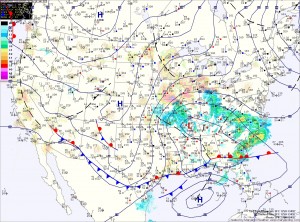
Current Surface Map
Current Surface Map
A potent storm system to our southwest is moving towards the region and will bring wintry weather to the area tonight and tomorrow.

If this were January 24th instead of March 24th, there would be no question that this would be a major winter storm for the entire region. Instead, despite an abundance of cold air aloft, the late March sun will warm the surface and result in a complicated forecast.

The models have come into a general agreement on the storm track and the amount of precipitation that falls and in the far western Maryland mountains where all snow is likely, totals near 12″ are likely. Accumulating snow will begin falling late this afternoon in this area.

Further east, mixing and warmer low level temperatures will complicate the forecast. Current thinking is that light rain or rain/snow mix will begin late this afternoon or evening, turning to all snow tonight.

Quiet to Begin the Weekend; Rain/Snow Likely Late Sunday

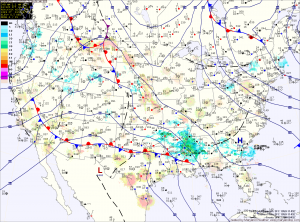
Current Surface Map
Current Surface Map
Expect mostly sunny skies and windy conditions today. Highs will be in the mid 40s.

Tomorrow will be similar to today, although not as windy. Clouds will begin to increase during the late afternoon in advance of a storm system that will begin to affect the area on Sunday. Highs will be in the low 50s.

An area of low pressure is expected to move northward to our west before dying out while another area forms off the coast. The exact placement, strength and timing of this transfer will determine precipitation types across the state.

Flurries This Morning; Breezy into the Weekend

Current Surface Map
Current Surface Map
Scattered flurries are pushing through the area this morning. This activity should end over the next hour or so. Expect breezy conditions through the afternoon under partly sunny skies. Highs today will only reach the upper 30s to around 40.

The end of the week and the first part of the weekend will be mostly sunny and breezy with highs in the mid to upper 40s.

Clouds will increase Saturday night as an area of low pressure approaches from the southwest. Models are coming into agreement that this storm will pass south of our area, keeping us on the cold side.

Rain/Snow Mix Developing

Current Surface Map
Current Surface Map
Light rain/snow/sleet is moving across the area this morning. The mix will continue into the afternoon before changing to rain in most places.

The exception is far western Maryland, where a Winter Storm Warning is in effect for several inches of snow. Further east, accumulations are not expected. Highs today will top out in the mid to upper 30s.

The cold front will pass through tonight, bringing an end to the precipitation. Tomorrow will feature decreasing clouds and gusty winds. Highs will be in the low 50s.

Rain/Snow Becoming All Snow

Current Surface Map
Current Surface Map
A Winter Storm Warning is in effect for all counties west of the Bay. A Winter Weather Advisory is in effect for the Eastern Shore. Yesterday’s forecast remains on track.

Projected Snow Totals by County:

12+”: Garrett
8-12″: Allegany, Washington
6-10″: Frederick, Carroll, Montgomery, Howard, N. Baltimore
4-8″: Anne Arundel, S. Baltimore, Baltimore City, Cecil, Harford, Kent, Prince Georges (the higher amounts further from the Bay)
2-4″: Calvert, Charles, Queen Annes, Talbot
1-3″: Caroline, Dorchester, St. Marys, Wicomico
Trace-1″: Somerset, Worcester

Currently, the area of low pressure is situated near the Tidewater of Virginia. As the low moves slowly eastward today, it will strengthen and winds in our area will shift from easterly to more northerly and colder air will be drawn in. As this happens, the rain and rain/snow mix will turn over to snow and become heavy at times as we move through the afternoon and into tonight.

Increasing Clouds Today; Heavy Snow Tomorrow

Current Surface Map
Current Surface Map
The biggest snowstorm in over 2 years will affect the area tonight and tomorrow. Today will feature increasing clouds with highs in the low to mid 40s.

Currently, a Winter Storm Warning is in effect for Allegany, Frederick, Garrett and Washington counties. A Winter Storm Watch remains in effect for the rest of the state west of the Bay.

Precipitation will overspread the state from west to east this afternoon and evening. In the mountains, it will start as snow, while further east, rain will develop and slowly transition to snow during the overnight.

By tomorrow morning, all areas west of the Bay will have transitioned to snow. Areas around and east of I-95 may mix with rain at times tomorrow morning, but the snow will continue, heavy at times through the day and into tomorrow night. Lower southern Maryland and the Eastern Shore will see more rain and have more mixing, cutting down storm totals. By tomorrow night, even these areas will see a period of all snow before it begins to taper off.

Mostly Sunny Today; Snow Likely Wednesday

Current Surface Map
Current Surface Map
High pressure will build into the area today, providing mostly sunny skies. Highs today will be in the low 40s.

Clouds will increase tomorrow, ahead of an area of low pressure that will move towards our area. Highs tomorrow will be in the low to mid 40s.

Expect light rain or light rain and snow to develop Tuesday evening. As the storm moves to our south, it will intensify and drag colder air into the area. This will change the rain over to snow late Tuesday night. Snow will continue through the day on Wednesday, tapering off Wednesday evening.

The marginal temperatures, combined with a March sun angle will work against accumulations, however with heavy snowfall rates, there is still a potential for a significant amount of accumulation of snow from this storm.

Dry and Cool into Next Week; Chance of Snow Midweek?

Current Surface Map
Current Surface Map
High pressure will continue to control our weather through the weekend and into next week.

Expect cool, dry and breezy conditions, with highs in the low to mid 40s through Tuesday. In western Maryland, expect scattered upslope snow showers to continue through the weekend.

As we move towards midweek, the models continue to show an area of low pressure moving through the southeast in some form or fashion.

There are discrepancies between what the low will do and if it will impact our area. In any case, the threat of a late season snowfall persists and if it were to occur, it would most likely be on Wednesday.

Scattered Showers Today

Current Surface Map
Current Surface Map
Batches of scattered showers are slowly moving through the area this morning and will continue to affect the state into the afternoon.

Highs today will be around 50 degrees.

Colder and drier air will move into the region tomorrow. Expect partly sunny skies with highs in the mid 40s.

A dry, cold and breezy weekend is on tap. Highs will be in the low to mid 40s on Saturday, and only around 40 on Sunday.

The dry stretch will continue into next week, with highs in the low 40s on Monday and Tuesday.

Light Rain Changing to Snow Tonight; Snow Tomorrow Night?

Current Surface Map
Current Surface Map
Clouds will increase today, ahead of two cold fronts that will move through this afternoon. Highs today will be in the mid 50s.

A small area of low pressure is expected to form along the front and move through this evening and tonight. Light rain will develop this evening and change to snow overnight. A light accumulation of around an inch is possible by tomorrow morning, especially along the Mason-Dixon line.

As the front moves off shore, the models are now leaning back towards developing a strong low pressure along it. Currently, it appears the low will develop far enough off shore to bring only a brief period of snow to the state Saturday night, before it moves northeast and brings heavier snow to New England.